Structuurweg, A2

61.0 km, 55 min

Head east on Kapittelhof25 m
Turn left to stay on Kapittelhof45 m
Turn left to stay on Kapittelhof70 m
Turn right onto Markt70 m
Continue onto Borchmolendijk350 m
Enter the traffic circle and take the 3rd exit onto Lindendijk50 m
Exit the traffic circle onto Lindendijk600 m
Continue onto Schijndelseweg700 m
Enter the traffic circle and take the 2nd exit towards Schijndel40 m
Exit the traffic circle towards Schijndel2.5 km
Continue onto Rooiseweg (N637)700 m
Continue onto Structuurweg1 km
Enter the traffic circle and take the 2nd exit onto Structuurweg35 m
Exit the traffic circle onto Structuurweg150 m
Keep right at the fork45 m
Make a slight left onto Structuurweg2 km
Enter the traffic circle and take the 2nd exit towards Molendijk40 m
Exit the traffic circle towards Molendijk550 m
Make a slight right to stay on Structuurweg90 m
Enter the traffic circle and take the 1st exit onto Structuurweg30 m
Exit the traffic circle onto Structuurweg1.5 km
Turn right onto Molendijk-Noord3 km
Continue onto Zuid-Willemsvaart150 m
Turn right to stay on Zuid-Willemsvaart100 m
Take the ramp on the right towards N279200 m
Merge left onto Zuid-Willemsvaart (N279)5 km
Take the ramp towards A2: Utrecht200 m
Continue right towards Nijmegen5 km
Keep left towards A2: Amsterdam30 km
Take exit 12 towards Everdingen400 m
Enter the traffic circle and take the 2nd exit towards A2: Amsterdam45 m
Exit the traffic circle towards A2: Amsterdam4 km
Take the ramp towards A27: Almere2.5 km
Take exit 27 towards Hagestein500 m
Turn right15 m
Turn right onto Hagenweg200 m
Keep left at the fork100 m
Turn right onto Ingenieur D S Tuijnmanweg600 m
Turn right onto Lange Dreef250 m
Turn left onto Industrieweg450 m
Turn right onto Stuartweg45 m
You have arrived at your destination, on the right0 m

Boxtelseweg, A2

65.7 km, 60 min

Head east on Kapittelhof25 m
Turn left to stay on Kapittelhof45 m
Turn left to stay on Kapittelhof150 m
Turn left onto Deken van Erpstraat A70 m
Continue onto Deken van Erpstraat B250 m
Turn left onto Hoge Vonderstraat55 m
Turn right onto Kofferen350 m
Continue onto Boskantseweg450 m
Turn left onto Leunestraat200 m
Enter the traffic circle and take the 1st exit towards Liempde10 m
Exit the traffic circle towards Liempde200 m
Continue onto Boskantseweg600 m
Turn right onto Liempdseweg1.5 km
Turn right onto Hulst2 km
Continue onto Meulekensweg700 m
Turn right onto Hezelaarsestraat550 m
Continue onto Vendelstraat550 m
Continue onto Kapelstraat300 m
Continue right onto Boxtelseweg1 km
Take the ramp on the right towards A2: 's-Hertogenbosch400 m
Merge left onto Rijksweg (A2)10 km
Keep left towards A2: Amsterdam35 km
Take exit 12 towards Everdingen400 m
Enter the traffic circle and take the 2nd exit towards A2: Amsterdam45 m
Exit the traffic circle towards A2: Amsterdam4 km
Take the ramp towards A27: Almere2.5 km
Take exit 27 towards Hagestein500 m
Turn right15 m
Turn right onto Hagenweg200 m
Keep left at the fork100 m
Turn right onto Ingenieur D S Tuijnmanweg600 m
Turn right onto Lange Dreef250 m
Turn left onto Industrieweg450 m
Turn right onto Stuartweg45 m
You have arrived at your destination, on the right0 m
From
    To

      Distance: 32.85 mi (52.86 km)

      Driving route: 37.93 mi (61.05 km)

      Driving time: 0h 54 minutes

      Distance from Sint-Oedenrode to Vianen

      The shortest distance (air line) between Sint-Oedenrode and Vianen is 32.85 mi (52.86 km).

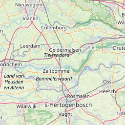
      The shortest route between Sint-Oedenrode and Vianen is 37.93 mi (61.05 km) according to the route planner. The driving time is approx. 0 h 54 m.

      How far is Sint-Oedenrode from Vianen

      Sint-Oedenrode is located in Noordoost-Noord-Brabant, Netherlands within 51° 33' 48.96" N 5° 27' 38.88" E (51.5636, 5.4608) coordinates. The local time in Sint-Oedenrode is 20:37 (19.02.2025)

      Vianen is located in Utrecht, Netherlands within 51° 58' 59.88" N 5° 5' 60" E (51.9833, 5.1000) coordinates. The local time in Vianen is 20:37 (19.02.2025)

      The calculated flying distance from Vianen to Vianen is 32.85 miles which is equal to 52.86 km.

      If you want to go by car, the driving driving distance between Sint-Oedenrode and Vianen is 37.93 miles (61.05 km). If you ride your car with an average speed of 112 km/h (70 miles/h), travel time will be 0 hours 33 minutes. Please check the avg. speed travel time on the right for various options.

      Estimated Travel Time Between Sint-Oedenrode and Vianen

      Average speedTravel Time
      30 mph (48 km/h)1 hours 16 minutes
      40 mph (64 km/h)0 hours 57 minutes
      50 mph (80 km/h)0 hours 46 minutes
      60 mph (67 km/h)0 hours 38 minutes
      70 mph (112 km/h)0 hours 33 minutes
      75 mph (120 km/h)0 hours 30 minutes

      Sint-Oedenrode, Noordoost-Noord-Brabant, Netherlands

      Related Distances from Sint-Oedenrode

      CitiesDistance
      Sint-Oedenrode to Eindhoven9.05 mi (14.57 km)
      Sint-Oedenrode to s-Hertogenbosch10.77 mi (17.33 km)
      Sint-Oedenrode to Tilburg16.24 mi (26.14 km)
      Sint-Oedenrode to Nijmegen26.09 mi (41.99 km)
      Sint-Oedenrode to Breda29.47 mi (47.42 km)
      Sint-Oedenrode to Arnhem34.94 mi (56.23 km)
      Sint-Oedenrode to Dordrecht37.16 mi (59.81 km)
      Sint-Oedenrode to Utrecht38.80 mi (62.44 km)
      Sint-Oedenrode to Amersfoort40.65 mi (65.42 km)
      Sint-Oedenrode to Rotterdam47.80 mi (76.93 km)
      Sint-Oedenrode to Apeldoorn50.02 mi (80.49 km)
      Sint-Oedenrode to Maastricht50.24 mi (80.85 km)
      Sint-Oedenrode to Alphen aan den Rijn51.94 mi (83.59 km)
      Sint-Oedenrode to Zoetermeer53.78 mi (86.55 km)
      Sint-Oedenrode to Almere56.45 mi (90.85 km)
      Sint-Oedenrode to Leiden58.43 mi (94.03 km)
      Sint-Oedenrode to The Hague60.73 mi (97.74 km)
      Sint-Oedenrode to Hoofddorp60.89 mi (98.00 km)
      Sint-Oedenrode to Amsterdam60.90 mi (98.01 km)
      Sint-Oedenrode to Haarlem66.69 mi (107.33 km)
      Sint-Oedenrode to Zaanstad69.03 mi (111.10 km)
      Sint-Oedenrode to Zwolle71.24 mi (114.64 km)
      Sint-Oedenrode to Enschede76.17 mi (122.59 km)
      Sint-Oedenrode to Leeuwarden113.88 mi (183.27 km)
      Sint-Oedenrode to Groningen123.37 mi (198.54 km)

      Vianen, Utrecht, Netherlands

      Related Distances to Vianen

      CitiesDistance
      Utrecht to Vianen6.95 mi (11.18 km)
      Amersfoort to Vianen16.66 mi (26.81 km)
      Alphen aan den Rijn to Vianen21.12 mi (34.00 km)
      Dordrecht to Vianen22.16 mi (35.67 km)
      s-Hertogenbosch to Vianen22.42 mi (36.08 km)
      Rotterdam to Vianen25.96 mi (41.78 km)
      Zoetermeer to Vianen26.15 mi (42.09 km)
      Almere to Vianen26.95 mi (43.37 km)
      Hoofddorp to Vianen28.26 mi (45.48 km)
      Amsterdam to Vianen28.30 mi (45.54 km)
      Leiden to Vianen28.64 mi (46.09 km)
      Tilburg to Vianen29.95 mi (48.19 km)
      Breda to Vianen30.57 mi (49.20 km)
      Nijmegen to Vianen33.82 mi (54.43 km)
      Haarlem to Vianen33.98 mi (54.69 km)
      The Hague to Vianen34.24 mi (55.10 km)
      Arnhem to Vianen34.75 mi (55.93 km)
      Zaanstad to Vianen36.29 mi (58.40 km)
      Apeldoorn to Vianen40.16 mi (64.64 km)
      Eindhoven to Vianen41.39 mi (66.62 km)
      Zwolle to Vianen56.10 mi (90.29 km)
      Enschede to Vianen78.08 mi (125.66 km)
      Maastricht to Vianen82.24 mi (132.35 km)
      Leeuwarden to Vianen88.82 mi (142.95 km)
      Groningen to Vianen105.12 mi (169.17 km)